AFTER HOURS EMERGENCIES
If high water levels are impacting you or your property, please submit a service request so that the appropriate staff receive the request immediately and there is a record of the request being made and action taken. If it is an after hours emergency where your home is at immediate risk, call (204) 904-9286. Please always call 911 if you are in a life threatening situation.
_________________________________________________________________________________________________________________________________________
Posted: April 21, 2026
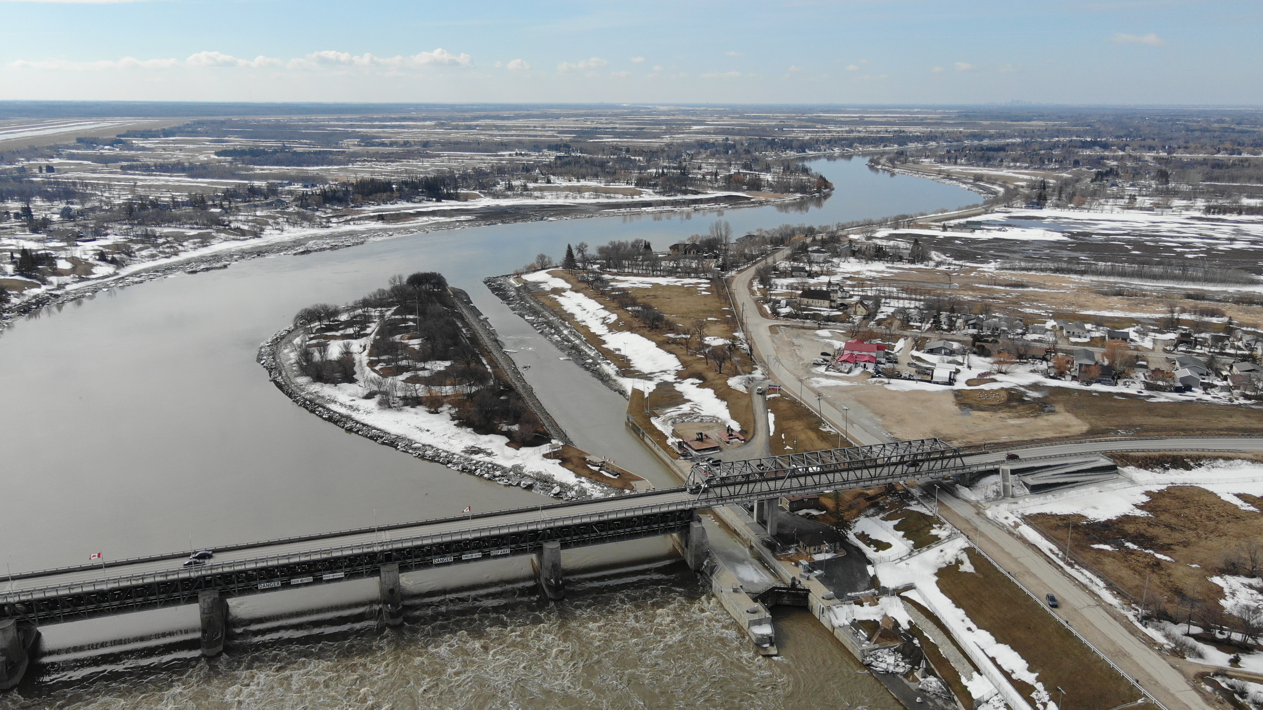
The RM of St. Andrews in coordination with Interlake Drone Services conducted the final flight of the 2026 Ice Monitoring Program on the Red River and Netley Creek. The ice has moved out of the Red River into Lake Winnipeg, and the RM is no longer concerned with the threat of ice jams.
However, the RM will continue to monitor spring runoff and weather conditions throughout the remainder of the season as part of our overarching Municipal Emergency Management Program.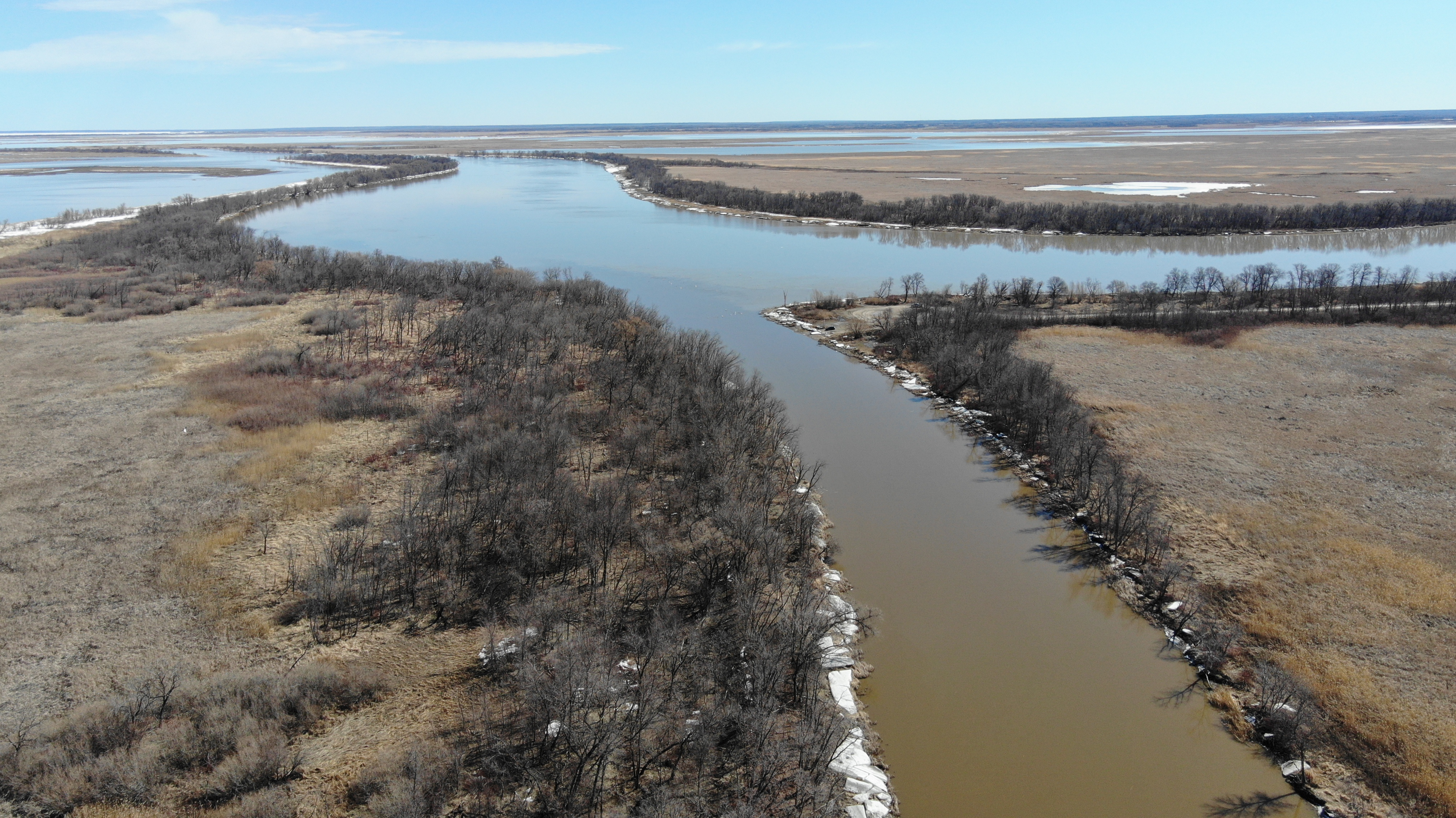
_________________________________________________________________________________________________________________________________________
Posted: April 15, 2026
Due to the road closure on Breezy Point Road, and increased water levels on the Netley Creek, the RM of St. Andrews conducted an unscheduled drone flight to observe significant ice rot on the creek and the ice pack has moved North past the Netley Marsh. As part of our ice surveillance program, we will continue to monitor over the upcoming weeks throughout the spring melt and post more photos and videos as things progress.
Our next scheduled flight will take place on April 20, 2026, weather permitting.
You can view the photos on our Flood Photos and Videos Page and the videos on our YouTube Channel under the Flood and High Water Events 2026 playlist. Imagery courtesy of Interlake Drone Services.
_____________________________________________________________________________________________________________________________________________________
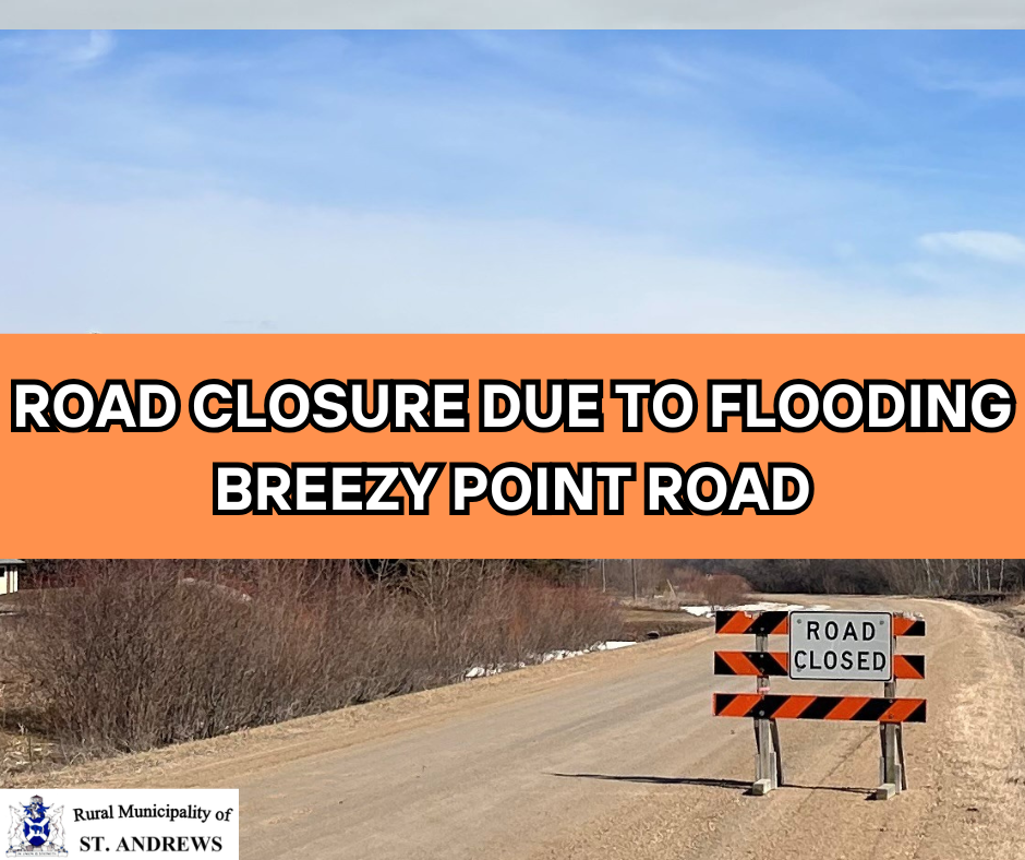
Posted: April 15, 2026
Please be advised that Breezy Point Road is currently closed due to flooding. The road will be closed until further notice. Thank you for your cooperation.
_________________________________________________________________________________________________________________________________________
Posted: April 13, 2026
Today we conducted our third drone flight to check the ice conditions on the Red River and Netley/Wavey Creek areas. The ice appears to be melting nicely along the edges, and fairly frozen still in most areas. As part of our ice surveillance program, we will continue to monitor over the upcoming weeks throughout the spring melt and post more photos and videos as things progress.
Our next scheduled flight will take place on April 20, 2026, weather permitting.
You can view the photos on our Flood Photos and Videos Page and the videos on our YouTube Channel under the Flood and High Water Events 2026 playlist. Imagery courtesy of Interlake Drone Services.
_________________________________________________________________________________________________________________________________________
______________________________________________________________________________________________________________________________________________________
Posted: April 7, 2026
Today we conducted our second drone flight to check the ice conditions on the Red River and Netley/Wavey Creek areas. The ice appears to still be frozen, with little change. As part of our ice surveillance program, we will continue to monitor over the upcoming weeks throughout the spring melt and post more photos and videos as things progress.
Our next scheduled flight will take place on April 13, 2026, weather permitting.
You can view the photos on our Flood Photos and Videos Page and the videos on our YouTube Channel under the Flood and High Water Events 2026 playlist. Imagery courtesy of Interlake Drone Services.
_________________________________________________________________________________________________________________________________________
Posted: March 30, 2026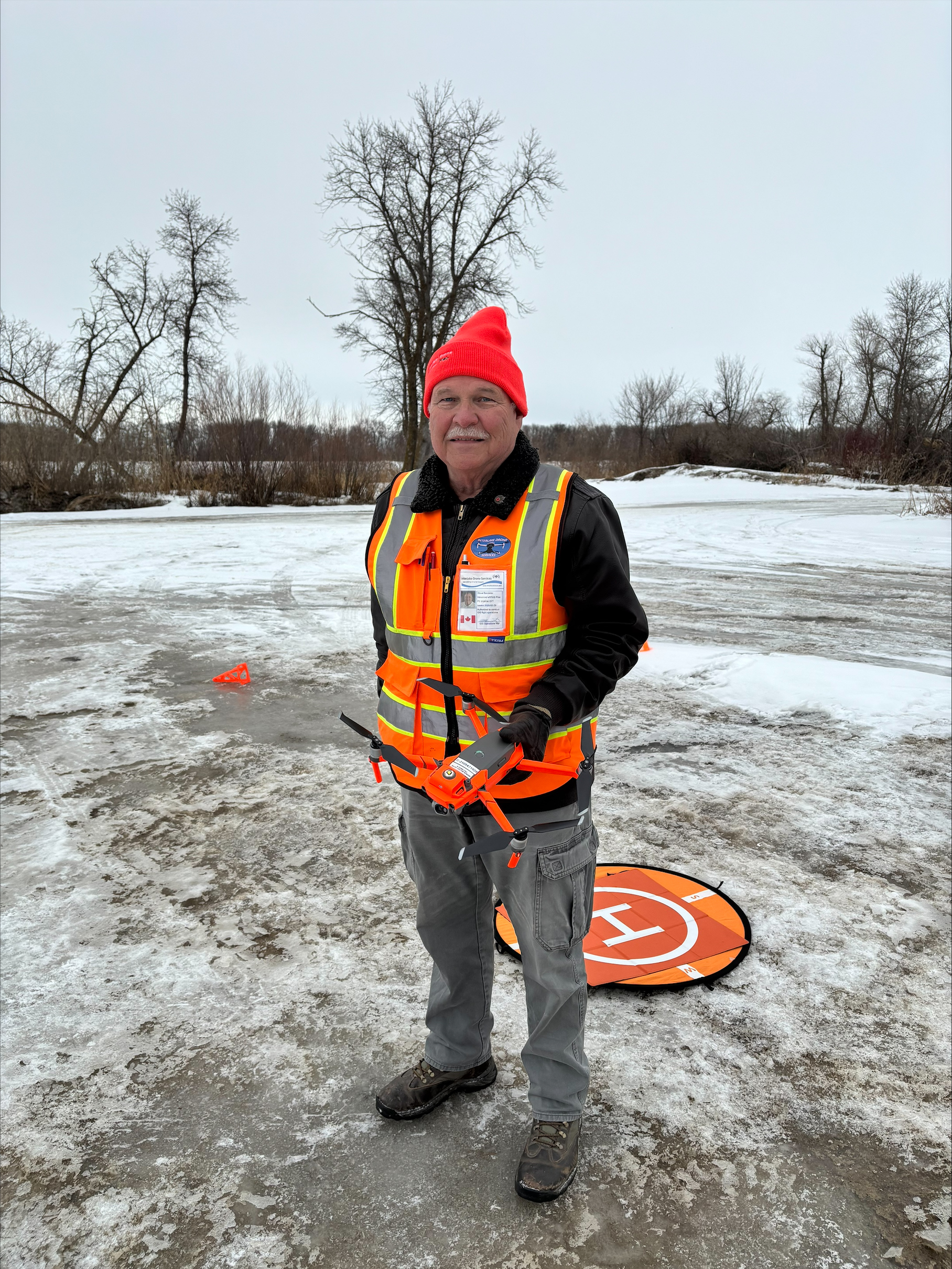
Today we conducted our first drone flight to check the ice conditions on the Red River and Netley/Wavey Creek areas. The ice appears to still be frozen in all areas. As part of our ice surveillance program, we will continue to monitor over the upcoming weeks throughout the spring melt and post more photos and videos as things progress.
Our next scheduled flight will take place on April 7, 2026, weather permitting.
You can view the photos on our Flood Photos and Videos Page and the videos on our YouTube Channel under the Flood and High Water Events 2026 playlist. Imagery courtesy of Interlake Drone Services.
_________________________________________________________________________________________________________________________________________


March 20, 2026
Province Issues March Flood Outlook
Low-to-Moderate Risk of Spring of Flooding Across Manitoba
Manitoba Transportation and Infrastructure’s Hydrologic Forecast Centre reports the risk of spring flooding is low to moderate for most Manitoba rivers heading into the spring runoff period, with the exception of the Fisher River basin in the Interlake Region which has a moderate to major flood risk.
Spring flood risk remains largely dependent on weather conditions from now through the melt period, including additional snowfall, spring rainfall and the timing and rate of snowmelt. The Hydrological Forecast Centre advises most Manitoba lakes are expected to remain within their desired operating ranges after spring runoff and the risk of flooding along Manitoba lakes is low. A moderate risk of flooding is in effect for the Red, Assiniboine and Souris rivers along with the Icelandic River in the Interlake region and portions of the Saskatchewan River in northern Manitoba.
Spring flood risk is moderate to major along the Fisher River. Flood risk is considered low for the Red and Assiniboine River tributaries, including the Pembina, Rat and Roseau rivers. Eastern Manitoba including the Winnipeg River basin and Whiteshell Lakes area and most Manitoba lakes also have a low risk of spring flooding.
Soil moisture at freeze-up was near-to below-normal across most of Manitoba, winter precipitation has ranged from near-to below-normal in many regions and soil frost depths are generally normal to shallower than normal, allowing normal to above-normal infiltration of meltwater.
Snow-water content across Manitoba basins indicated snow accumulations are generally within the normal range, except for parts of southern Manitoba where snow accumulation remains below typical values for this time of year. The Fisher river basin in the Interlake region has normal to above-normal snow water content.
Lake levels across the province are within their operating ranges. Lake Winnipeg and Lake Manitoba are well below normal for this time of year and inflows into most major lakes are expected to be below seasonal normals, reflecting generally drier-than-normal conditions across contributing river basins.
The Red River Floodway is not expected to be operated under normal or favourable weather conditions but may be operated under unfavourable conditions to reduce water levels within the City of Winnipeg. The Portage Diversion may be operated under unfavourable weather conditions or to mitigate ice-jamming on the lower Assiniboine River. The Shellmouth Reservoir is being operated in consultation with the Shellmouth Liaison Committee to reduce downstream flood risk while maintaining water supply and recreation objectives.
Ice-cutting and breaking activities are complete along the Red River and Icelandic River to reduce the risk of ice-jam flooding. There is a risk of jam induced flooding in areas that are historically affected by ice jams, including the Saskatchewan, Carrot, Swan, Icelandic and Fisher rivers.
Ice conditions and spring weather will play a key role in determining breakup timing and localized flooding potential.
Spring flood risk will continue to depend on weather conditions through the melt period. As temperatures warm and ice strength deteriorates, Manitobans are reminded to stay off waterways, rivers and retention ponds.
The Manitoba Emergency Management Organization continues to work with local authorities, First Nations and emergency management partners to prepare for potential spring flooding. This includes reviewing emergency plans, sharing information, and preparing resources for flood response, as well as coordination with Indigenous Services Canada and Manitoba Municipal and Northern Relations for First Nations and northern communities.
The 2026 spring flood outlook report is available at: https://www.gov.mb.ca/floodinfo/pdf/2026/march_2026_flood_outlook_report.pdf
______________________________________________________________________________________________________________________________________________________
February 25, 2026
MEDIA BULLETIN - MANITOBA - February 25, 2026 - Manitoba Transportation and Infrastructure’s Hydrologic Forecast Centre has released its February Flood Outlook Report, which indicates a low-to-moderate risk for most Manitoba basins.
Spring flood risk remains largely dependent on weather conditions from now through the melt period, including additional snowfall and spring rainfall, as well as the snowmelt’s timing and rate.
Most Manitoba lakes are expected to remain within desired operating ranges after spring runoff and the risk of flooding along Manitoba lakes is low.
A moderate risk of flooding is in effect for the Red, Pembina, Assiniboine, Souris and Qu’Appelle rivers, the Interlake region including the Icelandic and Fisher rivers, and portions of the Saskatchewan River in northern Manitoba. A low flood risk is in effect for Red and Assiniboine river tributaries including the Rat and Roseau rivers. Eastern Manitoba, including the Winnipeg River basin and Whiteshell lakes area, and most Manitoba lakes have low risk of spring flooding.
The Red River Floodway and the Portage Diversion are only expected to be operated under unfavourable weather conditions. Additionally, minimal operation of the Portage Diversion may be necessary to mitigate ice-related water level rises on the lower Assiniboine River (from Portage la Prairie to Winnipeg).
Outflow from the Shellmouth Dam is expected to increase today to 1,000 cubic feet per second (cfs) from the current 768 cfs. A further increase to 1,300 cfs will happen tomorrow as part of normal winter operations. This increase is expected to cause up to a two-foot rise in water levels along the Assiniboine River from Shellmouth to Brandon. The rise will diminish as the river approaches Winnipeg.
Manitoba Transportation and Infrastructure is conducting normal spring ice-cutting and breaking work along rivers to reduce ice-jam related flooding. Ice-cutting and breaking is currently underway on the Red River.
The Manitoba government, local authorities and First Nations communities are proactively preparing for any spring flooding. This includes reviewing emergency plans, information sharing between governments and preparing resources used in flood responses.
The 2026 spring flood outlook report is available at: https://gov.mb.ca/floodinfo/pdf/2026/february_2026_flood_outlook_report.pdf.
The next flood outlook is anticipated to be released in late March.
_______________________________________________________________________________________________________________________________________
December 12, 2025
Province Releases 2025 Fall Conditions Report
Manitoba Transportation and Infrastructure’s Hydrologic Forecast Centre has released the 2025 Manitoba Basins Fall Conditions Report, which provides an assessment of hydrologic conditions at the time of freeze-up for forecasting spring run-off. The report summarizes soil moisture conditions, river flows and lake level conditions, as well as an overview of long-range weather predictions heading into winter and spring.
Most Manitoba basins received below to well-below normal precipitation from May to October, while parts of southern Manitoba and the U.S. portions of the Red River basin and Souris River basin received normal to above-normal amounts. Soil moisture at freeze-up was near normal to above normal for parts of southern Manitoba and the U.S. portions of the Red River and Souris River basins. Record-low spring and summer precipitation in parts of the Interlake region, eastern Manitoba and northern Manitoba has contributed to drought-like conditions in these areas.
The report also includes a long-term precipitation outlook and projected river flows and lake levels across Manitoba basins:
- Global weather prediction centres indicate a weak La Niña climate conditions are expected to continue to early winter, with a transition toward neutral conditions from January to March.
- For Manitoba, La Niña weather patterns typically result in below-normal temperatures and above-normal precipitation from December through March.
- Most southern Manitoba rivers are near normal for this time of year, while most northern rivers remain below normal.
- Flows on the Red River and Assiniboine River are near normal for this time of year. Flows are below normal on the Saskatchewan River, and well-below normal on the Winnipeg and Churchill rivers.
- Most Manitoba lakes are at normal to below-normal levels and remain within their respective operating ranges.
- Lake Winnipeg and Lake Manitoba are well-below normal and Lake Winnipegosis is below normal for this time of year.
The near-normal to below-normal soil moisture conditions and near-normal to below-normal river levels indicate a potential for near-normal to below-normal spring run-off in most Manitoba basins. However, the extent of spring run-off is largely dependent on precipitation throughout the winter and spring and snowmelt conditions. A more detailed spring flood outlook is planned to be released later in February 2026.
The Hydrologic Forecast Centre works collaboratively with Environment and Climate Change Canada, the National Weather Service and flood forecasters in neighbouring jurisdictions to monitor watershed conditions and winter precipitation patterns. The Manitoba Emergency Management Organization continues proactive preparations for emergency response efforts in advance of spring run-off.
To read the 2025 Manitoba Basins Fall Conditions Report, visit: https://gov.mb.ca/floodinfo/pdf/2025/2025_fall_conditions_report.pdf
Posted: April 19, 2025
We launched our final drone flight today and things continue to progress nicely. The river has much less ice along the shorelines and is still wide open up to the cut. Netley Lake also appears to be showing more open water. Wavey Creek still has a lot of ice on it as it heads south from Netley Creek at Patricia Drive.
Netley Creek has some ice patches on it as it heads west from the river but has opened up more in the last few days. There is still a significant amount of ice once it gets to Patricia Drive and continues to head west. At PTH #9 it is wide open so somewhere in between PTH #9 and Patricia Drive the ice breaks up into open water. Once the warmer temperatures hit we will see that ice disappear quickly.
We hope everyone enjoyed getting a ‘birds eye view’ of the waterways this spring and fortunately, there were no emergencies to contend with.
A big thank you to Interlake Drone Services for once again flying for us and being a part of our emergency response efforts.
Have a wonderful Easter everyone!
Posted: April 15, 2025
Wow! What a difference a week makes.
We conducted our third drone flight today and since our last flight one week ago, there have been significant changes. Our last imagery on April 7 showed an ice covered river as well as creeks, but today the river is now open water all the way to ‘the cut’ with the exception of ice along the shorelines. Netley Lake still appears to have some ice on it.
Netley Creek heading west from the river is still quite frozen to where it meets with Wavey Creek at Patricia Drive. Wavey Creek also appears frozen for the most part but both creeks do have some small sections of water in different areas.
Based on the view from the air today, there appear to be no issues of concern at this time. Everything is looking great out there.
As for the water in municipal ditches, there has been less runoff from the fields this year, and the warm/cool temperatures have caused a slow and gradual melt which has eliminated any overland flooding issues.
The future forecast does not indicate any substantial amount of precipitation so we anticipate there will be no major concerns aside from some culverts requiring steaming in certain areas.
We expect to launch at least one more drone flight on Saturday, April 19, 2025 (weather permitting) and will see what changes have occurred along the creeks and any other areas.
Today's photos can be found on our Flood 2025 Photos and Videos page and the videos on our YouTube Channel under the Flood and High Water Events 2025 playlist.
You can also check the Province’s daily reports on river levels and flows at https://www.manitoba.ca/floodinfo/#forecasts_reports
If you do encounter any water issues or have other public works concerns, please remember to submit a service request.
Posted: April 7, 2025
Today we conducted our second drone flight to check how the ice has changed on the waterways north of Selkirk in the past week. There has been no significant change and everything still appears to be frozen due to the cooler weather. Warm temperatures are expected in the upcoming days which will escalate the ice melt and we will likely see things start to progress. There is currently open water in areas south of Lockport. Netley Lake at the end of the river at the cut appears to have some open water from the footage.
You can check out today's photos on our Flood 2025 Photos and Videos page and the videos on our YouTube Channel under the Flood and High Water Events 2025 playlist.
Our next flight is scheduled for Monday, April 15, 2025, weather permitting.
Municipal Ditches
As for municipal ditches, we expect that there will be a significant change with these warm temperatures in the upcoming days and there will be a heightened need for culvert steaming.
If you do experience water problems, please submit a service request so it gets into our tracking system. These requests get submitted immediately to our Public Works staff via email and it makes it easier for them to prioritize the submissions based on risk levels. If using your phone to submit a service request, you must download our App first and submit it through the App. A service request cannot be submitted on the phone without the App.
If you experience a high water emergency after hours, please call (204) 904-9286 and it will be forwarded to an on-call number, otherwise submit a service request or call the RM Office at (204) 738-2264 during regular business hours.
All messages will be rated on a priority scale and are ranked as follows:
1. House or Home
2. Outbuildings and Structures (Garages, Sheds etc.)
3. Yard sites
4. Fields
Please Note: Water on your lawn or around trees does not constitute a top priority.
Once the message has been triaged, a staff member will then inspect the site in order of priority to verify and determine if any corrective action is needed to be taken at that time.
Posted: March 31, 2025
Earlier today we conducted our first drone flight to check the ice conditions on the Red River and Netley/Wavey Creek areas. The ice appears to still be frozen in all areas. As part of our ice surveillance program, we will continue to monitor over the upcoming weeks throughout the spring melt and post more photos and videos as things progress.
Our next scheduled flight will take place on April 7, 2025, weather permitting.
You can view the photos on our Flood 2025 Photos and Videos page and the videos on our YouTube Channel under the Flood and High Water Events 2025 playlist. Imagery courtesy of Interlake Drone Services.

Posted: March 25, 2025
Media Bulletin - Manitoba - Spring Thaw Partially Begins in Southern Manitoba Basins
The Hydrologic Forecast Centre of Manitoba Transportation and Infrastructure is advising the public the spring thaw has partially started in southern Manitoba basins including the United States portion of the Red River basin. As temperatures rise, river flows and water levels are expected to gradually increase, leading to potentially hazardous ice conditions on rivers, lakes and drainage ditches throughout Manitoba.
While the ice may appear like normal winter ice, it may be very thin and will no longer support people and heavy objects such as snowmobiles and vehicles.
The Hydrologic Forecast Centre also advises outflows from the Shellmouth Dam are being reduced from the current 680 cubic feet per second (cfs) to 300 cfs as part of the normal operation of the dam. This reduction in outflow is expected to weaken the ice along the Assiniboine River from Shellmouth to Brandon.
Use of the rivers, lakes, floodways or drainage ditches for activities such as skiing, sledding and snowmobiling could be hazardous at this time and should be avoided. Persons living near such waterways should be especially careful to prevent children and pets from wandering onto the ice.
Daily temperatures are warming gradually and deteriorating ice thickness and strength. The quality of river ice within communities is also uncertain. Citizens are advised to stay off rivers and retention ponds.
The Manitoba Emergency Management Organization (EMO) continues to work with all local authorities and emergency management partners to provide guidance and support to prepare for and respond to spring flooding. This includes reviewing existing emergency plans, sharing information and preparing resources used in flood response. Additionally, Manitoba EMO continues to work with Indigenous Services Canada (ISC) and Municipal and Northern Relations (MNR) to support ISC and MNR-led preparation activities for First Nations and Northern Affairs communities.
As the melt continues, updated flood information will be available at www.manitoba.ca/floodinfo/.
Posted: March 25, 2025
The March 2025 Outlook Report prepared by the Hydrologic Forecast Centre (HFC) of Manitoba Transportation and Infrastructure reports a low to moderate risk of significant spring flooding across most Manitoba basins. However, flood risk remains dependent on future weather conditions, including precipitation levels and the rate of spring melt.
Soil Moisture, Precipitation, and Base Flows and Levels:
- Soil moisture at freeze-up is generally near normal to below normal for most Manitoba basins.
- Portions of the Red River basin in Manitoba and the U.S. have above normal to well above normal soil moisture.
- Portions of Northwestern Manitoba have well below normal soil moisture.
- Normal to below normal soil moisture levels thus far indicate a potential for near normal to below normal spring runoff within these river basins
- Winter precipitation for most of Manitoba watersheds has been normal to well above normal.
- Base flows and levels range generally from normal to above normal in most southern Manitoba basins and normal to below normal in central and northern Manitoba basins.
Flood Risk:
- The risk of significant flooding is low for many Manitoba basins, including the Red, Pembina, Rat, Roseau, Saskatchewan, Winnipeg and Churchill rivers.
- Levels on most Manitoba lakes are expected to be within their normal operating ranges after the spring runoff.
Future Weather:
- Short term weather forecast by Environment and Climate Change Canada indicates that there is less than a 50% chance of receiving more than 25 mm precipitation between March 21 and April 5, 2025, for most Manitoba basins.
Water Control Structures Operations:
- The Red River Floodway is not expected to be operated under normal and favourable weather conditions.
Ice Conditions & Safety:
- Ice cutting and breaking activities have been completed on the Red and Icelandic Rivers.
Next Steps:
- Manitoba Emergency Management Organization (Manitoba EMO) continues to work with local authorities, First Nations, and emergency management partners to provide guidance and support in spring flood preparedness and response. This includes reviewing emergency plans, sharing critical information, and coordinating resources for flood response.
To read the full March 2025 Flood Outlook, visit: www.manitoba.ca/floodinfo/pdf/2025/march_2025_flood_outlook_report.pdf
Posted: March 19, 2025
On February 27th, 2025, Manitoba Transportation and Infrastructure’s Hydrologic Forecast Centre released its February 2025 Flood Outlook Report which indicates a low-to-moderate risk of significant spring flooding across Manitoba basins. Spring flood risk is largely dependent on weather conditions from now until the spring melt and throughout the spring.
In preparation for the spring melt, RM staff are ensuring that all the necessary plans are in place and equipment ready.
- Culverts will be steamed where necessary.
- Drone footage will be done of the ice breakup on the river and posted on our YouTube Channel, website, X and Facebook page.
- The main drains will be cleared along with other problematic areas to allow the ditches to carry off the snow melt.
- Empty sandbags and sand will be available for those who require them.
A complete update on our Spring Public Works Operations including ditch clearing as well as spring melt preparations can all be found under Notices.
The potential for any overland and river flooding is low but the weather can change suddenly so we will be monitoring conditions over the upcoming weeks. We still ask that any necessary precautions be taken, especially if you have experienced problems with high water levels in the past.
If you do experience water problems, please submit a service request so it gets into our tracking system. These requests get submitted immediately to our Public Works staff via email and it makes it easier for them to prioritize the submissions based on risk levels. If using your phone to submit a service request, you must download our App first and submit it through the App. A service request cannot be submitted on the phone without the App.
Our flood information page will be used to provide any important updates along with links to the drone footage of the ice movement along the river. These videos and images assist us in monitoring the ice as it moves north for the potential risk of any ice jamming.
What you need to do if your property is at risk this spring?
- Empty sandbags will be available at the Public Works Shop in Clandeboye as well as our South Fire Hall at 5610 Highway #9. Sand will be available at the Public Works Yard in Clandeboye. Note: You will require your own shovel to fill the bags. Contact the RM Office at 204-738-2264 in advance if requiring bags and/or sand.
- Monitor the spring melt and watch for anything abnormal in your area and protect your home and property as necessary.
- Know the notification/warning systems the RM uses:
- Municipal website (www.rmofstandrews.com)
- X
- CONNECT Notification System (Text/Email/Phone Call - only if you have registered); if you haven't registered, sign up here: Register for CONNECT.
- Protect your pets and livestock.
- Take special precautions to safeguard electrical, natural gas or propane heating equipment. This may include turning off electricity to the affected areas of your home.
- Move furniture, electrical appliances, valuables and personal belongings to floors above ground level.
- Contact your insurer to make sure you are covered for flood insurance if your property is at risk.
- The RM is not responsible for individual property protection, does not deliver sandbags and will not provide staff to install them.
- Protect all openings, holding tanks, drinking water supply and septic fields that may be at risk.
There are some great fact sheets and resources of information on our Flood Fact Sheets page that can provide guidance and assistance in preparing for possible flooding situations.

Posted: February 27, 2025
MEDIA BULLETIN - MANITOBA - February 27, 2025 - Manitoba Transportation and Infrastructure’s Hydrologic Forecast Centre has released its February Flood Outlook Report, which indicates a low-to-moderate risk of significant spring flooding in most Manitoba basins.
Spring flood risk is largely dependent on weather conditions from now until the spring melt and throughout the spring.
Currently, there is a moderate risk of flooding along the Red, Assiniboine and Pembina rivers and in the Interlake region including the Fisher and Icelandic rivers. The risk of spring flooding is low along several other rivers, including the Roseau, Rat, Saskatchewan and Churchill rivers. Water levels are expected to remain below community flood protection levels. The risk of flooding is low for most Manitoba lakes throughout the spring period. Most lakes are expected to be within the desired operating ranges after the spring runoff.
The Red River Floodway and the Portage Diversion are only expected to be operated under unfavourable weather conditions. Additionally, minimal operation of the Portage Diversion may be necessary to mitigate ice-related water level rises on the lower Assiniboine River (from Portage la Prairie to Winnipeg).
The Shellmouth Reservoir is being operated in consultation with the Shellmouth liaison committee to reduce the risk of flooding downstream on the Assiniboine River, while also providing sufficient storage for water supply and recreation.
Manitoba Transportation and Infrastructure is conducting normal spring ice-cutting and breaking work along rivers to reduce ice-jam related flooding. Ice-cutting and breaking is currently underway on the Red River. Ice-cutting and breaking will start along the Icelandic River once breaking is completed along the Red River.
The Manitoba government, local authorities and First Nations communities are proactively preparing for any spring flooding. This includes reviewing emergency plans, information sharing between governments and preparing resources used in flood responses.
The 2025 spring flood outlook report is available at: www.gov.mb.ca/floodinfo/pdf/2025/february_2025_flood_outlook_report.pdf.
The next flood outlook is anticipated to be released in late March.

Province's Flood Outlook Information
To view the Province's latest flood outlook information and news releases, please click on the following link:
https://www.gov.mb.ca/flooding/index.html
To view the Government of Canada's Real-Time Hydrometic Data Graph for Netley Creek near Petersfield, please click on the following link: https://wateroffice.ec.gc.ca/report/real_time_e.html?stn=05OJ008
To view the Government of Canada's Real-Time Hydrometic Data Graph for Breezy Point, please click on the following link:
https://wateroffice.ec.gc.ca/report/real_time_e.html?stn=05OJ022
 CONNECT With St. Andrews